Top 10 hill Stations of India
Manali
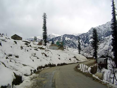
Manali (alt. 1,950 m or 6,398 ft), in the Beas River valley, is an important hill station in the mountains of
Himachal Pradesh, India, near the northern end of the Kullu Valley. It is located about 250 kilometres (155 mi) north of
state capital, Shimla.Manali is administratively a part of the Kullu district, with population of approx. 30,000.
The small town was the beginning of an ancient trade route to Ladakh and, from there, over the Karakoram Pass on to Yarkand
and Khotan in the Tarim Basin.Manali and the surrounding area is of great significance to Indian culture and heritage as
it is said to be the home of the Saptarshi, or Seven Sages.
Manali is a cosmopolitan town. People from different parts of India have settled here.The climate in Manali is predominantly
cold during winters, and moderately cool during summers. The temperatures range from 4 °C (39 °F) to 30 °C (86 °F) over
the year. The average temperature during summer is between 14 °C (57 °F) and 20 °C (68 °F), and between -7 °C (19.4 °F)
and 10 °C (50 °F) in the winter.
Main Places:
Naggar Fort:South of Manali is a reminder from the Pala Empire. Made from rocks, stones, and elaborate wood carvings,
it is an ensemble of the rich and elegant art works of Himachal. The castle was later converted to a hotel and is
currently under Himachal Tourism.
Hidimba Devi Temple:Erected in 1553, is dedicated to the local deity Hadimba, wife of the Pandava prince, Bhim.
The temple is noted for its four-store pagoda and exquisite wooden carvings.
Rahla waterfalls: lie some 27 km (17 mi) from Manali at the start of the climb to the Rohtang Pass, are the beautiful
Rahla Falls at an altitude of 2,501 m (8,205 ft).
Solang valley:Popularly known as Snow Point, is 13 km northwest of Manali.
Manikaran: located about 45 km. from kullu on the way to Manali is known for its hot spring near the river Parvati.
Shimla

Shimla formerly known as Simla, is the capital city of Himachal Pradesh. In 1864, Shimla was declared the summer capital
of the British Raj in India. A popular tourist destination, Shimla is often referred to as the “Queen of Hills,” a term
coined by the British. Located in the north-west Himalayas at an average altitude of 2,205 metres (7,234 ft), the
city of Shimla, draped in forests of pine, rhododendron, and oak, experiences pleasant summers and cold, snowy winters.
The city is famous for its buildings styled in tudorbethan and neo-gothic architecture dating from the colonial era.
Shimla is connected to the city of Kalka by one of the longest narrow gauge railway routes still operating in India,
the Kalka-Shimla Railway. Shimla is approximately 115 km (71.4 miles) from Chandigarh, the nearest major city, and 365 km
(226.8 miles) from New Delhi, the national capital. The city is named after the goddess Shyamala Devi, an incarnation of
the Hindu Goddess Kali.
Main Places:
The Mall: The Mall is the main shopping street of Shimla. It also has many restaurants, clubs, banks, bars, Post Offices
and tourist offices. The Gaiety Theatre is also situated there. People walk up and down the Mall slowly, stopping to gossip,
as it is the main meeting place for everyone. The Ridge and Scandal point are the two main meeting points at the Mall.
The mall is dotted with many eating places .The most famous among them is Trishul bakery which is known for its pastries.
Christ Church: Situated on the Ridge, Christ Church is the second oldest church in Northern India. It has a very majestic
appearance and inside there are stained glass windows which represent faith, hope, charity, fortitude, patience and humility.
Christ Church is a place all visitors should spend some time in.
Jakhu Hill: 2 km from Shimla, at a height of 8000 ft, Jakhu Hill is the highest peak and offers a beautiful view of the
town and of the snow-covered Himalayas. At the top of the Hill, is an old temple of Lord Hanuman, which is also the home of
countless playful monkeys waiting to be fed by all visitors.
Shimla State Museum: The Museum, which was opened in 1974, has tried to protect hill-out and the cultural wealth of the
state. There is a collection of miniature Pahari paintings, sculptures, bronzes wood-carvings and also costumes, textiles.
Gulmarg

Gulmarg is a town, a hill station and a notified area committee in Baramula district in the Indian area of
Jammu and Kashmir.Gulmarg is located 52 km from Srinagar.Gulmarg can be accessed from Srinagar (the capital of Kashmir)
in about 2 hours by car or bus. The buses will reach Tangmarg in about 1 hour. From Tangmarg, for the 13 km hill road,
jeeps can be hired for reaching Gulmarg hilltop in about 30 minutes. Some searches and identity checks may take place
about 5 km before Gulmarg. The last jeep down from Gulmarg is available at sunset.
Gulmarg has around 40 hotels of all grades. The peak season starts with the snow fall in December and lasts until June.
The charges for one night stay in off season range between Rs500 – Rs5000+. The off-season rates may have a discount of
about 60% in some of the hotels only.
According to CNN, Gulmarg is the “heartland of winter sports in India.” As such, The Gulmarg Health Resort has been rated
by CNN International as Asia’s seventh best ski destination.This resort is famous because of its “Gulmarg Gondola,”
the highest cable car in the world, reaching 3,979 metres.
Srinagar

Srinagar is the capital of the northernmost Indian state of Jammu and Kashmir. It is situated in Kashmir Valley and
lies on the banks of the Jhelum River, a tributary of the Indus. While not the largest, it is one of the biggest cities
in India without a Hindu majority.[4] The city is famous for its lakes and houseboats. It is also known for traditional
Kashmiri handicrafts and dry fruits. It is also the headquarters of Srinagar district.
The city is located on both the sides of the Jhelum River, which is called Vyath in Kashmir. The river passes through
the city and meanders through the valley, moving onward and deepening in the Wular Lake. The city is famous for its nine
old bridges, connecting the two parts of the city.
Tourism is the most significant segment of the city’s economy. The city of Srinagar is a gateway to some of the most
scenic and beautiful places of the Indian subcontinent. The hill station and skiing resort Gulmarg is 50 km from the city.
For decades, tourism has been contributing massively to the economy of the city, but it has been adversely affected on
account of insurgent activities by certain elements.The areas on the outskirts of Srinagar are also famous for their natural
beauty. Also in this area lies the Muzaffarabad Cantonement, which is the main cantonement of the Indian Army in Srinagar
District(the name of the Cantt. is often confused with Muzaffarabad city which is a separate city in Pakistan Occupied
Kashmir.Srinagar is well known for its lakes. Dal Lake is known for its houseboats. Nagin Lake is another famous lake
in the city.
Srinagar has several gardens which are part of the several such gardens laid by the Mughal emperors across the Indian
subcontinent, and which are known as Mughal gardens.The Tulip Gardens have been recently opened to public by Mrs Sonia
Gandhi. The gardens has rows of Tulips of different colurs and shades.
Dalhousie

Dalhousie is a Municipal Town and popular tourist spot in Chamba district of Himachal Pradesh State, India.Dalhousie
experiences winter-like cold climate throughout the year. Heavy rain with thunder showers are experienced during the
period from June to September. In May–July it is usually warm in the morning and afternoon but gets cold early in the
evening and quite cold at night. The weather becomes very cold during winter and if it rains. Dalhousie also experiences
snow during the peak of winter period in December and January. Being a hill station, Dalhousie is famous for its salubrious
climate.
As a hill station, Dalhousie accommodates many Boarding Schools. Children from Punjab and Haryana are the majority of
students in the schools.
Dalhousie has many places to visit. A favorite spot for tourists is the area near Alla. It is a potato field and it
offers mesmerizing scenic landscape. Another popular spot is the area of Karelanu. It is famous for its precious water
which healed a great leader, Subhash Chandra Bose. He was suffering from tuberculosis and he regularly drank the water
from the natural spring there and he was healed.
Important Areas:
.Gandhi Chowk
.Diankund
.Bakrota Hills
.Dalhousie Cantonment
.Sadar Bazar
.Tibetan Market
.Panchpula
Rohtang Pass

Rohtang Pass is a high mountain pass on the eastern Pir Panjal Range of the Himalayas some 51 km (32 mi) from Manali.
It connects the Kullu Valley with the Lahaul and Spiti Valleys of Himachal Pradesh, India.
The pass provides a natural divide between the sub-humid/humid Kullu Valley with a primarily Hindu culture (in the south),
and the arid/semi-arid high-altitude Lahaul and Spiti valleys with a Buddhist culture (in the north). The pass lies on the
watershed between the Chenab and Beas Basins. On the southern side of this pass, the Beas River emerges from underground
and flows southward and on its northern side, the Chandra River, a source stream of the river Chenab, flows westward.
The pass is open from May to November. It is not particularly high or difficult to cross on foot by Himalayan standards,
but it has a well-deserved reputation for being dangerous because of unpredictable snowstorms and blizzards.
This pass is an ancient trade route between the people on either side of Pir Panjal. The local name for this pass is a
generic name of pass. There are many other passes in Lahaul and Spiti which have specific names . This is suggestive of
the fact that this must have been the oldest and most frequented pass in the region, or the fact that it is the main pass
leading from one cultural region (Indian) to another, quite different one, to the north.
Lahaul and Spiti

The district of Lahaul-Spiti in the Indian state of Himachal Pradesh consists of the two formerly separate districts of
Lahaul and Spiti. The present administrative centre is Keylong in Lahaul. Before the two districts were merged, Kardang was
the capital of Lahaul, and Dhankar the capital of Spiti.
The two valleys are quite different in character. Spiti is more barren and difficult to cross, with an average elevation
of the valley floor of 4,270 m (14,009 ft). It is enclosed between lofty ranges, with the Spiti river rushing out of a
gorge in the southeast to meet the Sutlej River. It is a typical mountain desert area with an average annual rainfall of
only 170 mm (6.7 inches).
The natural scenery and Buddhist monasteries, such as Ki, Dhankar, Shashur, Guru Ghantal and Tayul Gompas, are the main
tourist attractions of the region.One of the most interesting places is the Tabo Monastery, located 45 km from Kaza,
Himachal Pradesh, the capital of the Spiti region. This monastery rose to prominence when it celebrated its thousandth
year of existence in 1996. It houses a collection of Buddhist scriptures, Buddhist statues and Thangkas. The ancient gompa
is finished with mud plaster, and contains several scriptures and documents. Lama Dzangpo heads the gompa here. There is a
modern guest house with a dining hall and all facilities are available.
Spiti is one of the important centers of Buddhism in Himachal Pradesh. It is popularly known as the ‘land of lamas’.
The valley is dotted by numerous Buddhist Monasteries or Gompas that are famous throughout the world and are a favorite
of Dalai Lama.
Skiing is the popular adventure sports in Spiti and is popular in India from the past few years. The amazing snow
clad mountains with the added advantage of inspiring heights are enough to allure the adventure spirits of the avid skier,
providing all the thrill and fun attracted to the sport. People from all around the globe come to experience this
enthralling adventure activity.
Leh

Leh was the capital of the Himalayan kingdom of Ladakh, now the Leh District in the state of Jammu and Kashmir, India.
Leh, with an area of 45,110 km2, is the second largest district in the country (after Kutch, Gujarat) in terms of area.
The town is still dominated by the now ruined Leh Palace, former mansion of the royal family of Ladakh, built in the same
style and about the same time as the Potala Palace. Leh is at an altitude of 3524 meters (11,562 ft). National Highway 1D
connects it to Srinagar in the northwest.
Leh has a cold desert climate with long, harsh winters from October to early March, with minimum temperatures well
below freezing for most of the winter. The city gets occasional snowfall during winter. The weather in the remaining
months is generally fine and warm during the day.
Leh is connected to the rest of India by two high-altitude roads both of which are subject to landslides and neither
of which are passable in winter when covered by deep snows. The National Highway 1D from Srinagar via Kargilis generally
open longer. The Leh-Manali Highway can be troublesome due to very high passes and plateaus , and the lower but
landslide-prone Rohtang Pass near Manali.
Leh’s Leh Kushok Bakula Rimpochee Airport has flights to Delhi at least daily on Kingfisher, Jet Airways and/or Indian
Airlines which also provides twice weekly services to Jammu and a weekly flight to Srinagar. Connect in Delhi for other
destinations.
Khandala

Khandala is a hill station in the Western Ghats in the state of Maharashtra, India, about three kilometres from Lonavala
and seven kilometers from Karjat.Khandala is located at one (top) end the Bhor Ghat, a major ghat (meaning valley in Marathi)
on the road link between the Deccan Plateau and the Konkan plain. The ghat carries an extensive amount of road and rail
traffic. The Mumbai-Pune Expressway, the main link between the major cities of Mumbai and Pune, passes through Khandala.
Due to the ease of accessibility from nearby cities, Khandala is a common area for hiking. One destination is the nearby
peak of Duke’s Nose, which offers a panaromic view of Khandala and the Bhor Ghat.
The town was mentioned in a popular song from the Hindi film Ghulam named “Aati kya Khandala?” (“Will you come to Khandala?”).
Ashok Kumar’s character in the 1975 classic Chhoti Si Baat is a retired army Colonel that lives in Khandala.
Nainital

Nainital is a town in the Indian state of Uttarakhand and headquarters of Nainital district in the Kumaon foothills
of the outer Himalayas. Situated at an altitude of 1,938 metres (6,358 feet) above sea level, Nainital is set in a
valley containing a pear-shaped lake, approximately two miles in circumference, and surrounded by mountains, of which
the highest are Naina (2,615 m (8,579 ft)) on the north, Deopatha (2,438 m (7,999 ft)) on the west, and Ayarpatha
(2,278 m (7,474 ft)) on the south. From the tops of the higher peaks, “magnificent views can be obtained of the vast
plain to the south, or of the mass of tangled ridges lying north, bounded by the great snowy range which forms the
central axis of the Himalayas.
Nainital has temperate summers, maximum temperature 27 °C ,minimum temperature 7 °C , during which its population increases
more than fivefold with an annual influx of tourists predominantly from the plains of Northern India.In the winter,
Nainital receives snowfall between December and February with the temperatures varying between a maximum of
15 °C and a minimum of -3 °C .
It is believed that Nainital figures in some ancient myths of India. In the Manas Khand of the Skand Puranas, Nainital
Lake is called Tri-Rishi-Sarovar.
In Nainital, the Naina Devi Temple was destroyed by the landslip of 1880 and later rebuilt. It is located on the northern shore of
Naini Lake. The presiding deity of the temple is Maa Naina Devi represented by two Netras or eyes. Flanking Naina Devi
are the deities of Mata Kali and Lord Ganesha.
Bhimtal Lake is named after the second Pandava brother Bhima in the Mahabharata who was known for his prodigious strength.
The lake, which is larger than Naini Lake, is approximately 22 km (14 mi) from Nainital at an altitude of 1,370 m (4,495 ft).
There is an island in the lake with a popular restaurant on it. There is also a 17th century temple complex, the Bhimeshwar,
alongside a 40 ft (12 m) high dam at one end of the lake.

Manali (alt. 1,950 m or 6,398 ft), in the Beas River valley, is an important hill station in the mountains of
Himachal Pradesh, India, near the northern end of the Kullu Valley. It is located about 250 kilometres (155 mi) north of
state capital, Shimla.Manali is administratively a part of the Kullu district, with population of approx. 30,000.
The small town was the beginning of an ancient trade route to Ladakh and, from there, over the Karakoram Pass on to Yarkand
and Khotan in the Tarim Basin.Manali and the surrounding area is of great significance to Indian culture and heritage as
it is said to be the home of the Saptarshi, or Seven Sages.
Manali is a cosmopolitan town. People from different parts of India have settled here.The climate in Manali is predominantly
cold during winters, and moderately cool during summers. The temperatures range from 4 °C (39 °F) to 30 °C (86 °F) over
the year. The average temperature during summer is between 14 °C (57 °F) and 20 °C (68 °F), and between -7 °C (19.4 °F)
and 10 °C (50 °F) in the winter.
Main Places:
Naggar Fort:South of Manali is a reminder from the Pala Empire. Made from rocks, stones, and elaborate wood carvings,
it is an ensemble of the rich and elegant art works of Himachal. The castle was later converted to a hotel and is
currently under Himachal Tourism.
Hidimba Devi Temple:Erected in 1553, is dedicated to the local deity Hadimba, wife of the Pandava prince, Bhim.
The temple is noted for its four-store pagoda and exquisite wooden carvings.
Rahla waterfalls: lie some 27 km (17 mi) from Manali at the start of the climb to the Rohtang Pass, are the beautiful
Rahla Falls at an altitude of 2,501 m (8,205 ft).
Solang valley:Popularly known as Snow Point, is 13 km northwest of Manali.
Manikaran: located about 45 km. from kullu on the way to Manali is known for its hot spring near the river Parvati.
Shimla
Shimla formerly known as Simla, is the capital city of Himachal Pradesh. In 1864, Shimla was declared the summer capital
of the British Raj in India. A popular tourist destination, Shimla is often referred to as the “Queen of Hills,” a term
coined by the British. Located in the north-west Himalayas at an average altitude of 2,205 metres (7,234 ft), the
city of Shimla, draped in forests of pine, rhododendron, and oak, experiences pleasant summers and cold, snowy winters.
The city is famous for its buildings styled in tudorbethan and neo-gothic architecture dating from the colonial era.
Shimla is connected to the city of Kalka by one of the longest narrow gauge railway routes still operating in India,
the Kalka-Shimla Railway. Shimla is approximately 115 km (71.4 miles) from Chandigarh, the nearest major city, and 365 km
(226.8 miles) from New Delhi, the national capital. The city is named after the goddess Shyamala Devi, an incarnation of
the Hindu Goddess Kali.
Main Places:
The Mall: The Mall is the main shopping street of Shimla. It also has many restaurants, clubs, banks, bars, Post Offices
and tourist offices. The Gaiety Theatre is also situated there. People walk up and down the Mall slowly, stopping to gossip,
as it is the main meeting place for everyone. The Ridge and Scandal point are the two main meeting points at the Mall.
The mall is dotted with many eating places .The most famous among them is Trishul bakery which is known for its pastries.
Christ Church: Situated on the Ridge, Christ Church is the second oldest church in Northern India. It has a very majestic
appearance and inside there are stained glass windows which represent faith, hope, charity, fortitude, patience and humility.
Christ Church is a place all visitors should spend some time in.
Jakhu Hill: 2 km from Shimla, at a height of 8000 ft, Jakhu Hill is the highest peak and offers a beautiful view of the
town and of the snow-covered Himalayas. At the top of the Hill, is an old temple of Lord Hanuman, which is also the home of
countless playful monkeys waiting to be fed by all visitors.
Shimla State Museum: The Museum, which was opened in 1974, has tried to protect hill-out and the cultural wealth of the
state. There is a collection of miniature Pahari paintings, sculptures, bronzes wood-carvings and also costumes, textiles.
Gulmarg

Gulmarg is a town, a hill station and a notified area committee in Baramula district in the Indian area of
Jammu and Kashmir.Gulmarg is located 52 km from Srinagar.Gulmarg can be accessed from Srinagar (the capital of Kashmir)
in about 2 hours by car or bus. The buses will reach Tangmarg in about 1 hour. From Tangmarg, for the 13 km hill road,
jeeps can be hired for reaching Gulmarg hilltop in about 30 minutes. Some searches and identity checks may take place
about 5 km before Gulmarg. The last jeep down from Gulmarg is available at sunset.
Gulmarg has around 40 hotels of all grades. The peak season starts with the snow fall in December and lasts until June.
The charges for one night stay in off season range between Rs500 – Rs5000+. The off-season rates may have a discount of
about 60% in some of the hotels only.
According to CNN, Gulmarg is the “heartland of winter sports in India.” As such, The Gulmarg Health Resort has been rated
by CNN International as Asia’s seventh best ski destination.This resort is famous because of its “Gulmarg Gondola,”
the highest cable car in the world, reaching 3,979 metres.
Srinagar

Srinagar is the capital of the northernmost Indian state of Jammu and Kashmir. It is situated in Kashmir Valley and
lies on the banks of the Jhelum River, a tributary of the Indus. While not the largest, it is one of the biggest cities
in India without a Hindu majority.[4] The city is famous for its lakes and houseboats. It is also known for traditional
Kashmiri handicrafts and dry fruits. It is also the headquarters of Srinagar district.
The city is located on both the sides of the Jhelum River, which is called Vyath in Kashmir. The river passes through
the city and meanders through the valley, moving onward and deepening in the Wular Lake. The city is famous for its nine
old bridges, connecting the two parts of the city.
Tourism is the most significant segment of the city’s economy. The city of Srinagar is a gateway to some of the most
scenic and beautiful places of the Indian subcontinent. The hill station and skiing resort Gulmarg is 50 km from the city.
For decades, tourism has been contributing massively to the economy of the city, but it has been adversely affected on
account of insurgent activities by certain elements.The areas on the outskirts of Srinagar are also famous for their natural
beauty. Also in this area lies the Muzaffarabad Cantonement, which is the main cantonement of the Indian Army in Srinagar
District(the name of the Cantt. is often confused with Muzaffarabad city which is a separate city in Pakistan Occupied
Kashmir.Srinagar is well known for its lakes. Dal Lake is known for its houseboats. Nagin Lake is another famous lake
in the city.
Srinagar has several gardens which are part of the several such gardens laid by the Mughal emperors across the Indian
subcontinent, and which are known as Mughal gardens.The Tulip Gardens have been recently opened to public by Mrs Sonia
Gandhi. The gardens has rows of Tulips of different colurs and shades.
Dalhousie

Dalhousie is a Municipal Town and popular tourist spot in Chamba district of Himachal Pradesh State, India.Dalhousie
experiences winter-like cold climate throughout the year. Heavy rain with thunder showers are experienced during the
period from June to September. In May–July it is usually warm in the morning and afternoon but gets cold early in the
evening and quite cold at night. The weather becomes very cold during winter and if it rains. Dalhousie also experiences
snow during the peak of winter period in December and January. Being a hill station, Dalhousie is famous for its salubrious
climate.
As a hill station, Dalhousie accommodates many Boarding Schools. Children from Punjab and Haryana are the majority of
students in the schools.
Dalhousie has many places to visit. A favorite spot for tourists is the area near Alla. It is a potato field and it
offers mesmerizing scenic landscape. Another popular spot is the area of Karelanu. It is famous for its precious water
which healed a great leader, Subhash Chandra Bose. He was suffering from tuberculosis and he regularly drank the water
from the natural spring there and he was healed.
Important Areas:
.Gandhi Chowk
.Diankund
.Bakrota Hills
.Dalhousie Cantonment
.Sadar Bazar
.Tibetan Market
.Panchpula
Rohtang Pass

Rohtang Pass is a high mountain pass on the eastern Pir Panjal Range of the Himalayas some 51 km (32 mi) from Manali.
It connects the Kullu Valley with the Lahaul and Spiti Valleys of Himachal Pradesh, India.
The pass provides a natural divide between the sub-humid/humid Kullu Valley with a primarily Hindu culture (in the south),
and the arid/semi-arid high-altitude Lahaul and Spiti valleys with a Buddhist culture (in the north). The pass lies on the
watershed between the Chenab and Beas Basins. On the southern side of this pass, the Beas River emerges from underground
and flows southward and on its northern side, the Chandra River, a source stream of the river Chenab, flows westward.
The pass is open from May to November. It is not particularly high or difficult to cross on foot by Himalayan standards,
but it has a well-deserved reputation for being dangerous because of unpredictable snowstorms and blizzards.
This pass is an ancient trade route between the people on either side of Pir Panjal. The local name for this pass is a
generic name of pass. There are many other passes in Lahaul and Spiti which have specific names . This is suggestive of
the fact that this must have been the oldest and most frequented pass in the region, or the fact that it is the main pass
leading from one cultural region (Indian) to another, quite different one, to the north.
Lahaul and Spiti

The district of Lahaul-Spiti in the Indian state of Himachal Pradesh consists of the two formerly separate districts of
Lahaul and Spiti. The present administrative centre is Keylong in Lahaul. Before the two districts were merged, Kardang was
the capital of Lahaul, and Dhankar the capital of Spiti.
The two valleys are quite different in character. Spiti is more barren and difficult to cross, with an average elevation
of the valley floor of 4,270 m (14,009 ft). It is enclosed between lofty ranges, with the Spiti river rushing out of a
gorge in the southeast to meet the Sutlej River. It is a typical mountain desert area with an average annual rainfall of
only 170 mm (6.7 inches).
The natural scenery and Buddhist monasteries, such as Ki, Dhankar, Shashur, Guru Ghantal and Tayul Gompas, are the main
tourist attractions of the region.One of the most interesting places is the Tabo Monastery, located 45 km from Kaza,
Himachal Pradesh, the capital of the Spiti region. This monastery rose to prominence when it celebrated its thousandth
year of existence in 1996. It houses a collection of Buddhist scriptures, Buddhist statues and Thangkas. The ancient gompa
is finished with mud plaster, and contains several scriptures and documents. Lama Dzangpo heads the gompa here. There is a
modern guest house with a dining hall and all facilities are available.
Spiti is one of the important centers of Buddhism in Himachal Pradesh. It is popularly known as the ‘land of lamas’.
The valley is dotted by numerous Buddhist Monasteries or Gompas that are famous throughout the world and are a favorite
of Dalai Lama.
Skiing is the popular adventure sports in Spiti and is popular in India from the past few years. The amazing snow
clad mountains with the added advantage of inspiring heights are enough to allure the adventure spirits of the avid skier,
providing all the thrill and fun attracted to the sport. People from all around the globe come to experience this
enthralling adventure activity.
Leh

Leh was the capital of the Himalayan kingdom of Ladakh, now the Leh District in the state of Jammu and Kashmir, India.
Leh, with an area of 45,110 km2, is the second largest district in the country (after Kutch, Gujarat) in terms of area.
The town is still dominated by the now ruined Leh Palace, former mansion of the royal family of Ladakh, built in the same
style and about the same time as the Potala Palace. Leh is at an altitude of 3524 meters (11,562 ft). National Highway 1D
connects it to Srinagar in the northwest.
Leh has a cold desert climate with long, harsh winters from October to early March, with minimum temperatures well
below freezing for most of the winter. The city gets occasional snowfall during winter. The weather in the remaining
months is generally fine and warm during the day.
Leh is connected to the rest of India by two high-altitude roads both of which are subject to landslides and neither
of which are passable in winter when covered by deep snows. The National Highway 1D from Srinagar via Kargilis generally
open longer. The Leh-Manali Highway can be troublesome due to very high passes and plateaus , and the lower but
landslide-prone Rohtang Pass near Manali.
Leh’s Leh Kushok Bakula Rimpochee Airport has flights to Delhi at least daily on Kingfisher, Jet Airways and/or Indian
Airlines which also provides twice weekly services to Jammu and a weekly flight to Srinagar. Connect in Delhi for other
destinations.
Khandala

Khandala is a hill station in the Western Ghats in the state of Maharashtra, India, about three kilometres from Lonavala
and seven kilometers from Karjat.Khandala is located at one (top) end the Bhor Ghat, a major ghat (meaning valley in Marathi)
on the road link between the Deccan Plateau and the Konkan plain. The ghat carries an extensive amount of road and rail
traffic. The Mumbai-Pune Expressway, the main link between the major cities of Mumbai and Pune, passes through Khandala.
Due to the ease of accessibility from nearby cities, Khandala is a common area for hiking. One destination is the nearby
peak of Duke’s Nose, which offers a panaromic view of Khandala and the Bhor Ghat.
The town was mentioned in a popular song from the Hindi film Ghulam named “Aati kya Khandala?” (“Will you come to Khandala?”).
Ashok Kumar’s character in the 1975 classic Chhoti Si Baat is a retired army Colonel that lives in Khandala.
Nainital

Nainital is a town in the Indian state of Uttarakhand and headquarters of Nainital district in the Kumaon foothills
of the outer Himalayas. Situated at an altitude of 1,938 metres (6,358 feet) above sea level, Nainital is set in a
valley containing a pear-shaped lake, approximately two miles in circumference, and surrounded by mountains, of which
the highest are Naina (2,615 m (8,579 ft)) on the north, Deopatha (2,438 m (7,999 ft)) on the west, and Ayarpatha
(2,278 m (7,474 ft)) on the south. From the tops of the higher peaks, “magnificent views can be obtained of the vast
plain to the south, or of the mass of tangled ridges lying north, bounded by the great snowy range which forms the
central axis of the Himalayas.
Nainital has temperate summers, maximum temperature 27 °C ,minimum temperature 7 °C , during which its population increases
more than fivefold with an annual influx of tourists predominantly from the plains of Northern India.In the winter,
Nainital receives snowfall between December and February with the temperatures varying between a maximum of
15 °C and a minimum of -3 °C .
It is believed that Nainital figures in some ancient myths of India. In the Manas Khand of the Skand Puranas, Nainital
Lake is called Tri-Rishi-Sarovar.
In Nainital, the Naina Devi Temple was destroyed by the landslip of 1880 and later rebuilt. It is located on the northern shore of
Naini Lake. The presiding deity of the temple is Maa Naina Devi represented by two Netras or eyes. Flanking Naina Devi
are the deities of Mata Kali and Lord Ganesha.
Bhimtal Lake is named after the second Pandava brother Bhima in the Mahabharata who was known for his prodigious strength.
The lake, which is larger than Naini Lake, is approximately 22 km (14 mi) from Nainital at an altitude of 1,370 m (4,495 ft).
There is an island in the lake with a popular restaurant on it. There is also a 17th century temple complex, the Bhimeshwar,
alongside a 40 ft (12 m) high dam at one end of the lake.
Mount Abu Tour of Rajasthan

Nakki Lake

Green Lake
Mount Abu Road


Mount Abu View

Dilwara Temple

Ambaji Temple, Mount Abu
More information :-http://www.topz10s.com/top-10-hill-stations-india-2
The hill stations of India have great charm and appeal us to come here again and again. I really like them and always prefer to go there as they make me feel like I am taking a walk of nature. for more information about hil stations in india click here
ReplyDeletehi,great work done by u,If u want to njoy this summer vacation in a different way the please visit bandipur resorts its a very nice place near mysore
ReplyDeleteStrolling ias the activity in which people like to wandering with lots of enjoyments. Lahaul and Spiti are the places where several people like to tour and strolling for their needs like buy ancient show-pieces from shops and enjoying the foods of restaurants where they get different kinds of varieties of dishes and like to buying woolen clothes from show-rooms.
ReplyDeleteYour photography skills are top-notch. Every picture tells a story and leaves me in awe. Click here Leh Ladakh Pangong Lake Tour Package
ReplyDelete